Saturday, February 4, 2012
Sunday, July 17, 2011
Baja California, July 2011
After months of planning and requesting vacation time, My friend Marc and I left on Saturday, July 9th for our week long road trip to Baja. We didn't have a specific itinerary in place, but we were hoping to be in Baja during any kind of South Swell activity and look to do some camping and surfing for a couple of days before deciding on the next part of our road trip.
We stayed in Ensenada on Saturday, getting into town in just the nick of time to check in at our hotel, and go look for a mechanic that was still open. The goal was to celebrate my buddy Marc's birthday and to finally finish the Land Cruiser's dual battery set up with the help of a local mechanic, who cut and made the proper connectors which I purchased at West Marine in Dana Point that same day. Glad to report that we had no problems operating the 12V fridge which kept things cold for the trip. I even had an opportunity to test the main, or starting battery (idea is to use the auxiliary battery to power the fridge and accessories like the radio and interior lights while the car is parked for a few days.) after I realized that the 2nd battery had lost power on the third day of camping at Punta Baja.
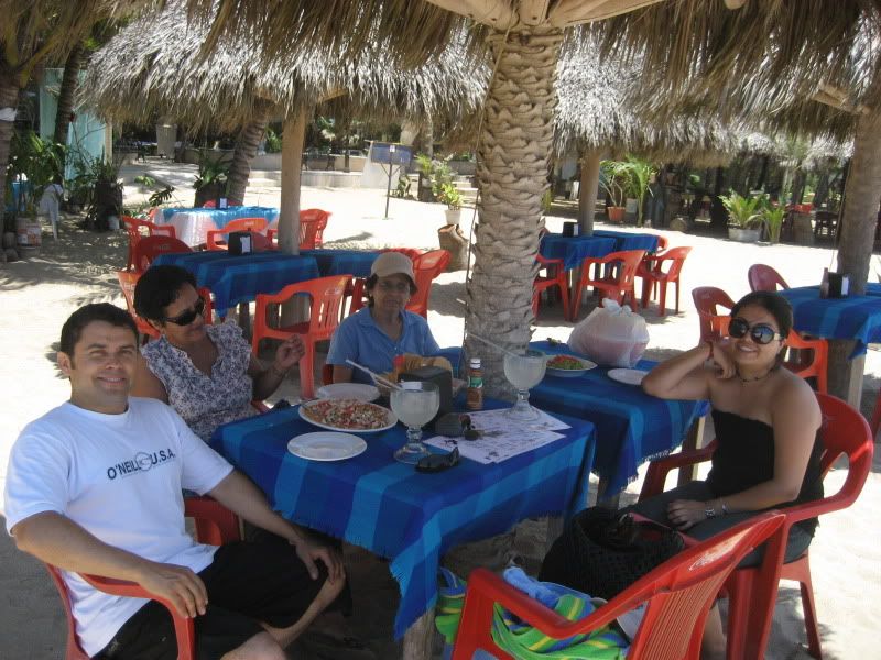
Sunday morning we left Ensenada heading south on highway 1 and shortly outside of town we came across three nicely modified Toyota Land Cruisers one drive by Jan, a member of the mud forum and who had shared that he and his friends were also were going to be driving down into Baja on Sunday morning and heading to Bahia De Los Angeles. We drove caravaned for a few miles, until some time later Jan and friends stopped at a Pemex gas station and we continued driving south for a planned stop at San Quintin, have some lunch, and pick up last minute supplies before heading out to a local break. We had a nice seafood lunch a a local restaurant in San Quintin. I wish I could have written the name of the place, but the food was delicious, (I had grilled oysters and fish tacos.) and the bathrooms very clean.
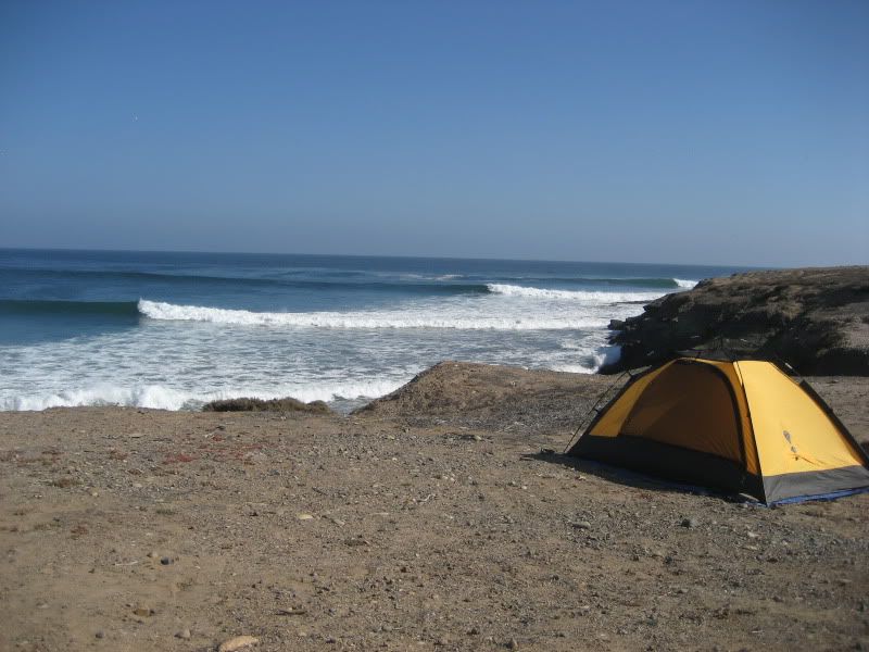
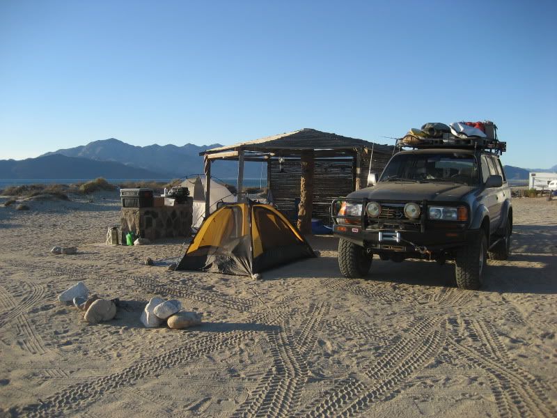
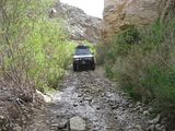
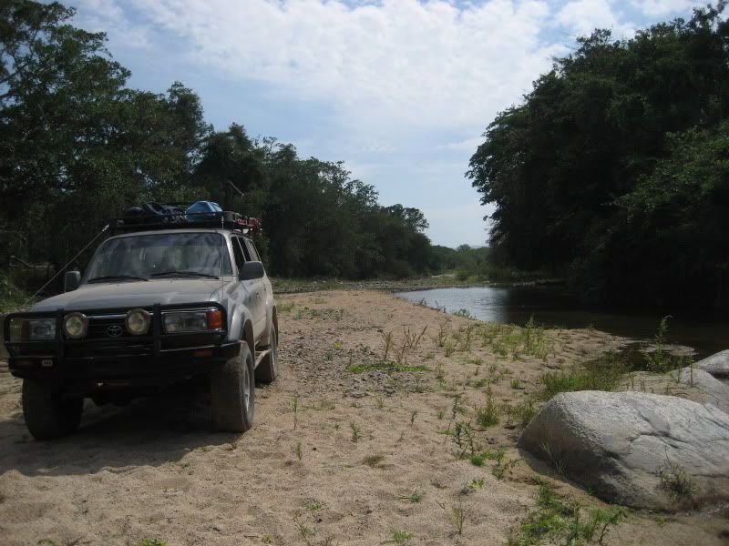
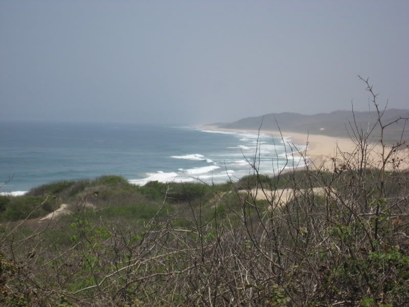
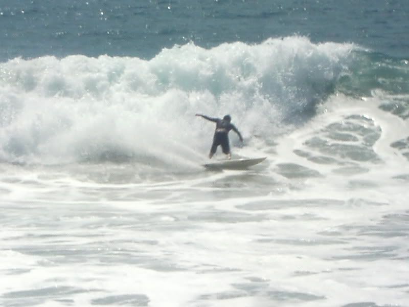
The surf report was calling for a South Swell in the shoulder to head high range and looking at wave breaks with optimum south swell directions, we focused on reaching Punta Baja, a point break near El Rosario, a couple of hundred miles south of Ensenada. Once we got to El Rosario some time past 2 pm (who keeps time in Baja?) I turned on my Garmin GPS, and laptop topo mapping software to guarantee that I was following the right dirt road track into Punta Baja. It was turning out to be a great, warm sunny day.) After driving for about 30 minutes or so, we get to Punta Baja, which to our luck was blessing us with 3-4 foot waves breaking along its great point break set up. We decided to set up camp, prop our tents up before going out for a late after noon session.
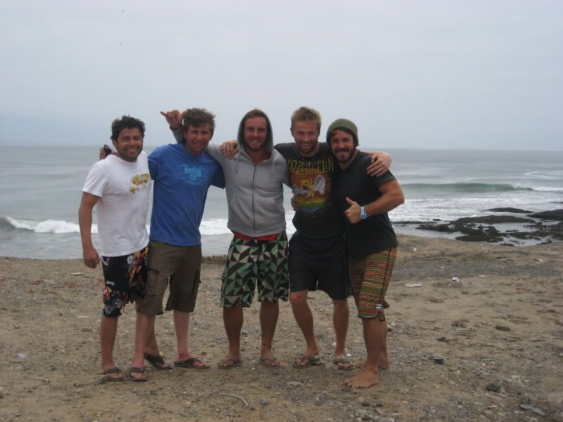
After we were surfed out and thinking about dinner that night over a cold Tecate, a red Ford van with wood racks drives over, and 2 gentlemen wave at us, greet us and asked if they could share the cliff with us and camp near us. It turns out that there were 3 Aussies in the van, and after they introduced themselves, and got a chance to chat with us, it was agreed that it would also be a good idea for safety reasons for them to pitch their tent fairly close to our camp site. Ben, Ben, and Matt, the 3 blokes from Sydney turned out to be great company, nice guys in their 20s who were in the first couple of months of travel out of a year's worth of travel plans having started in the US, and now Baja, before catching a ferry over to the mainland, but not before flying out of La Paz to meet up with a couple of friends in Cuba for a week. Lucky guys and good them.
During the next couple of days we did nothing but relax, share travel stories, and surf. On Monday I got up at 6 am (like I usually do) and went out for a solo morning surf session and got the point to myself for a good hour and a half, that is until I started getting cold and tired. :) It was a great moment of my trip, being out surfing alone, and sharing the point with only 2 seals who kept very close to me, always poking their heads and staring at me. All of us had a great time while at Punta Baja, taking time to explore a bit, collect drift wood for the evening and morning fire, and me securing some fresh fish from a local fisherman to have a nice dinner on Monday night, coupled with a tasty pico de gallo salsa which I had prepared earlier that day in between my surf sessions. The boys were loving the grilled fish fillets. I threw a corn in the fire for the extra detail. Who says you have to rough it when you are camping?
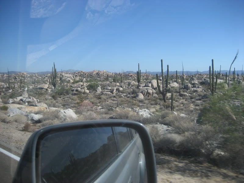
After having some lunch with the Aussies at El Rosario and heading over to the local Pemex gas station before saying our last so longs, The red van showed a gas leak which concerned the Aussies. I recommended we find a local mechanic to check things closely, something we had no problems finding in El Rosario. After some trouble shooting the local mecanico identified the culprit, nothing but a rubber hose near the fill up area which a large crack. He ended up finding the same diameter hose at the local reffaccionaria (200 pesos) and doing the labor for $100 pesos. I took the opportunity to have another mecanico change to oil in my truck since it was over due (I had the oil filter and engine oil with me.) With the Ford van's problem identified and knowing that soon the boys would be back on the road, we decided to get a jump on the day and headed south for Bahia De Los Angeles. I want to say it took us about 5 hours to make it into Bahia De Los Angeles after leaving El Rosario. Driving south of El Rosario, you find some picturesque vistas once inside the Valley of the Cirios, the Spanish word for Cardons, enormous cati that dot the rocky desert land scape. You not only find Cardon cacti, but many other types of cacti growing in this beautiful area that reminds me a whole lot of some areas within Joshua Tree National Park. We reached Bahia De Los Angeles a little past 7 PM. We had decided to enjoy some hot temperatures, and warm, Sea of Cortez water, where we could do some snorkeling and perhaps even rent a kayak, or fish (disclosure, I didn't pick up a fishing pole during he whole week I was in Baja, Marc did but didn't catch any fish.)
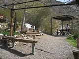
We found the Palapa closest to the water at Dagget's RV and beach camp and made it home for the next 2 days. The routine was simple, stay out of the sun during the hottest times of the day, stay hydrated with water or beer, and keep dipping in the water to cool off. That simple routine was the reason for heading over to this picturesque bay in the first place. Goal: do little. The snorkeling was fun and tranquil, there were species of fish and native kelp beds to explore, with the occasional spotting of sting rays, and plenty of blow fish.
Thursday morning it was time to move on, but not before Marc cooked some nice scrambled eggs, and cooked turkey bacon. We also enjoyed a nice cup of coffee with milk, like we did every morning. After packing up, we set off for our next destination, which after some thought we agreed it was time to get back to the Pacific Coast and do some exploration. We didn't necessarily feel the need to go further south, so we turned north to get back to the general area near Punta Baja.
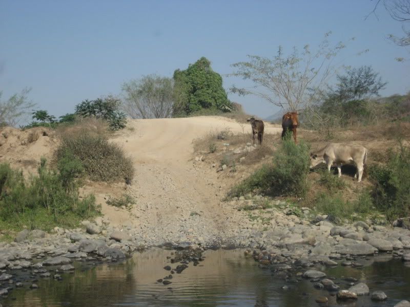
We got off the highway 1 a few miles past the town of Gauyaquil, and followed an improved road south then west some 38 miles to Punta San Carlos. It turns out, Punta San Carlos is a fishing town with an airline strip, and gets good exposure to swells, and because it is a windy point, it is very popular with the sail board, and wind surfing crowds. Now, we were hoping to find similar wind and weather as Punta Baja not too far north. Sadly, that was not the case. While there still was a south swell in the chest high range, it was very windy and cold. Too windy for our taste. After having some lunch, we decided to continue north to see if we would find better wind conditions. We drove north on a dirt road, with a times some cool desert landscapes that reminded of Anza Borrego which took us past Campo Nuevo, also I believe to be known as Punta San Fernando, another nice right point break that was breaking about the same size as Punta San Carlos, but with less windy, and more of a side shore. Of course, there was nobody out, and the nearest home was about a quarter mile south. There was a nice bluff over looking the waves, and it could have well been the camp site we could have stayed at, had my buddy Marc not have reservations about staying there alone by ourselves (security issues, and as a precaution.) Good enough, I wasn't going to argue that point, so after siphoning the gas from the 2 spare gas cans, we continued north zigzagging east to north west with the ocean coming in view many times until we got to the fishing camp named Agua Blanca, which at that point, we decided to take the trail that got us into El Rosario. About 83 miles of dirt road driving later and after having gotten off highway 1 originally, we got into El Rosario.
We looked for the only RV and Camping place in El Rosario, and finding out the rooms could be had cheap ($20 dls. For the room with 2 twin beds,) we decided to skip sleeping in a tent that night. During the evening we went over to a taqueria and had some nice grilled carne asada tacos, and after wards I looked for people who could use some of my clothes that I took with me to donate and stoked a few people out, including the taquero's son who at his young age is already looking burly, probably from eating all those tasty tacos he gets to enjoy.
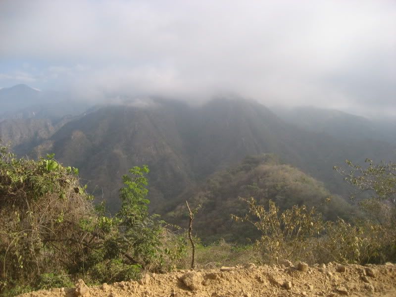
Friday morning I gave Marc the option for our next destination. One option was to drive over to Punta San Jose, not far from the town of Santo Tomas. I was curious about seeing Punta San Jose, and this trip could have been the time to see it. However, I was also curious about potentially getting to the San Pedro Martir Observatory, located in Parque Nacional de San Pedro Martir, the first of 2 national parks established in Baja California. The observatory is located at an elevation of 9280 feet, and it is supposed to be a great way to spend a day getting to know that little seen place of Baja. Once in the neighborhood, we had to option of staying the night at Rancho Meling, or drive the tough trail near from the vicinity to Mike's Sky Ranch, a popular place for the Baja racers and off road crowd.
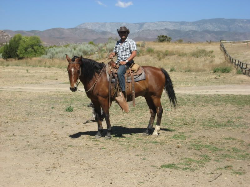
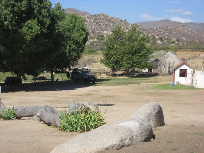
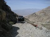
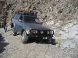
Once in the vicinity of the Parque Nacional de San Pedro Martir, we realized we would not have enough time to get to the Observatory and partake on the guided tour, which was open till 1pm. So we decided to find the trail that could take us to Mike's Sky Ranch, some 9 miles away on the trail. The trail leading to Mike's Sky ranch has a reputation for being a tough trail with some technical passes, and a high ground clearance 4 wheel drive vehicle is recommended. We were good here, no problems, but not having taken the time to research about the trail's recent shape gave us some surprises not too far away once we got on the trail. The first one was an off camber pass near a ravine, the third and final one after crossing a semi dry creek with large rocks was the end of our intent to get to Mike's Sky ranch. It was a section of the trail that had been washed away leaving for a very narrow pass, that only ATVs and narrow wheel base 4 wheel drive could make. At that point we decided to put the land cruiser in reverse, cross the creek in reverse, where right after it was about the only place to turn it around and go back. I decided it was best for me to spot Marc driving on these technical passes to make sure he could follow the lines I felt comfortable him to follow. While short lived, the trail gave us plenty of adrenalin moments. I just know I need to go back some day with a group of experienced off roaders who are familiar with this trail and tackle it again. Since Rancho Meling was being occupied by a family group and there fore closed to non family visitors, we opted for Rancho El Coyote instead. Marc and I found Rancho El Coyote much to our liking, the ranch was located in a nice area, and had nice cabins, for rent, a very nice camping area with trees, barbecue pits, and grass where one could pitch a tent. It also had a very clean pool to enjoy, combined with horse back riding, and I believe guides to head into the back country. Marc decided to skip on the horse back riding experience, thus I rode solo (my horse's name was Bartolo) and enjoy an hour of solitude.
The night was cool, and we enjoyed a full moon that illuminated the hills sharply. Around 4 AM we were woken up by a rooster's crow who possibly was warning his hens about a Coyote in the neighborhood. This was confirmed after the ranch dogs (mostly Australian Shepherds) started a raucous and all went after the intruder. After a few minutes of this, it was finally peacefully quiet again and we would go back to sleep.
Saturday morning came, and after some coffee and oatmeal for breakfast, we broke down camp and got on the road to get home. It was time to head back up to Southern California.
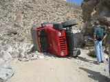
Never during the trip did we feel a concern for our safety, nor heard about any crime activity while we were in Baja. The only thing we drove by was the scene of an accident after the tow truck had just secured the rolled over vehicle onto its flat bed and was starting to drive away. It was another case of a car going over the side and flipping (Baja roads are notorious for lacking a shoulder, so if your tire goes over, you have a good risk of flipping the vehicle since the paved roads tend to be above a certain higher elevation than the ground next to it.) We fueled one last time in the outskirts of Ensenada, where we enjoyed some nice birria from a local stand, and after I stopped by super mercado Levy for a bottle of tequila and Kahlua, we drove straight to Tijuana where once there we got in line to cross the border at San Ysidro's border crossing.
As always, count of wasting about 2 hours of your life idling on the long traffic lines when crossing. And once we got to our US Customs officer, we got sent to secondary inspection because we failed to declare some the eggs that were still in the fridge (I guess the fact that we bought the eggs in the US was still not ok because they crossed into Mexico and were at risk of being contaminated? OK, it didn't make any sense to me but I wasn't about to argue.) Luckily the secondary inspection was that detailed, they made us throw out the eggs, and 1 mango that was also in the fridge, and the officers were polite, and truthfully, probably wanted to avoid having to go through so much camping gear stuff in the car in order to do a thorough search.
That wrapped up another great week in Baja Mexico. I am looking forward of going back in the near future once time and work obligations allow. Baja California is still a place where you can find solitude, and slow down the clock, loosing yourself in the many places you can benefit from, depending on the activities you are into. Great times.
link to more trip pics here. You will have to cut and paste the photobucket link on another page.
We stayed in Ensenada on Saturday, getting into town in just the nick of time to check in at our hotel, and go look for a mechanic that was still open. The goal was to celebrate my buddy Marc's birthday and to finally finish the Land Cruiser's dual battery set up with the help of a local mechanic, who cut and made the proper connectors which I purchased at West Marine in Dana Point that same day. Glad to report that we had no problems operating the 12V fridge which kept things cold for the trip. I even had an opportunity to test the main, or starting battery (idea is to use the auxiliary battery to power the fridge and accessories like the radio and interior lights while the car is parked for a few days.) after I realized that the 2nd battery had lost power on the third day of camping at Punta Baja.
Sunday morning we left Ensenada heading south on highway 1 and shortly outside of town we came across three nicely modified Toyota Land Cruisers one drive by Jan, a member of the mud forum and who had shared that he and his friends were also were going to be driving down into Baja on Sunday morning and heading to Bahia De Los Angeles. We drove caravaned for a few miles, until some time later Jan and friends stopped at a Pemex gas station and we continued driving south for a planned stop at San Quintin, have some lunch, and pick up last minute supplies before heading out to a local break. We had a nice seafood lunch a a local restaurant in San Quintin. I wish I could have written the name of the place, but the food was delicious, (I had grilled oysters and fish tacos.) and the bathrooms very clean.
The surf report was calling for a South Swell in the shoulder to head high range and looking at wave breaks with optimum south swell directions, we focused on reaching Punta Baja, a point break near El Rosario, a couple of hundred miles south of Ensenada. Once we got to El Rosario some time past 2 pm (who keeps time in Baja?) I turned on my Garmin GPS, and laptop topo mapping software to guarantee that I was following the right dirt road track into Punta Baja. It was turning out to be a great, warm sunny day.) After driving for about 30 minutes or so, we get to Punta Baja, which to our luck was blessing us with 3-4 foot waves breaking along its great point break set up. We decided to set up camp, prop our tents up before going out for a late after noon session.
After we were surfed out and thinking about dinner that night over a cold Tecate, a red Ford van with wood racks drives over, and 2 gentlemen wave at us, greet us and asked if they could share the cliff with us and camp near us. It turns out that there were 3 Aussies in the van, and after they introduced themselves, and got a chance to chat with us, it was agreed that it would also be a good idea for safety reasons for them to pitch their tent fairly close to our camp site. Ben, Ben, and Matt, the 3 blokes from Sydney turned out to be great company, nice guys in their 20s who were in the first couple of months of travel out of a year's worth of travel plans having started in the US, and now Baja, before catching a ferry over to the mainland, but not before flying out of La Paz to meet up with a couple of friends in Cuba for a week. Lucky guys and good them.
During the next couple of days we did nothing but relax, share travel stories, and surf. On Monday I got up at 6 am (like I usually do) and went out for a solo morning surf session and got the point to myself for a good hour and a half, that is until I started getting cold and tired. :) It was a great moment of my trip, being out surfing alone, and sharing the point with only 2 seals who kept very close to me, always poking their heads and staring at me. All of us had a great time while at Punta Baja, taking time to explore a bit, collect drift wood for the evening and morning fire, and me securing some fresh fish from a local fisherman to have a nice dinner on Monday night, coupled with a tasty pico de gallo salsa which I had prepared earlier that day in between my surf sessions. The boys were loving the grilled fish fillets. I threw a corn in the fire for the extra detail. Who says you have to rough it when you are camping?
After having some lunch with the Aussies at El Rosario and heading over to the local Pemex gas station before saying our last so longs, The red van showed a gas leak which concerned the Aussies. I recommended we find a local mechanic to check things closely, something we had no problems finding in El Rosario. After some trouble shooting the local mecanico identified the culprit, nothing but a rubber hose near the fill up area which a large crack. He ended up finding the same diameter hose at the local reffaccionaria (200 pesos) and doing the labor for $100 pesos. I took the opportunity to have another mecanico change to oil in my truck since it was over due (I had the oil filter and engine oil with me.) With the Ford van's problem identified and knowing that soon the boys would be back on the road, we decided to get a jump on the day and headed south for Bahia De Los Angeles. I want to say it took us about 5 hours to make it into Bahia De Los Angeles after leaving El Rosario. Driving south of El Rosario, you find some picturesque vistas once inside the Valley of the Cirios, the Spanish word for Cardons, enormous cati that dot the rocky desert land scape. You not only find Cardon cacti, but many other types of cacti growing in this beautiful area that reminds me a whole lot of some areas within Joshua Tree National Park. We reached Bahia De Los Angeles a little past 7 PM. We had decided to enjoy some hot temperatures, and warm, Sea of Cortez water, where we could do some snorkeling and perhaps even rent a kayak, or fish (disclosure, I didn't pick up a fishing pole during he whole week I was in Baja, Marc did but didn't catch any fish.)
We found the Palapa closest to the water at Dagget's RV and beach camp and made it home for the next 2 days. The routine was simple, stay out of the sun during the hottest times of the day, stay hydrated with water or beer, and keep dipping in the water to cool off. That simple routine was the reason for heading over to this picturesque bay in the first place. Goal: do little. The snorkeling was fun and tranquil, there were species of fish and native kelp beds to explore, with the occasional spotting of sting rays, and plenty of blow fish.
Thursday morning it was time to move on, but not before Marc cooked some nice scrambled eggs, and cooked turkey bacon. We also enjoyed a nice cup of coffee with milk, like we did every morning. After packing up, we set off for our next destination, which after some thought we agreed it was time to get back to the Pacific Coast and do some exploration. We didn't necessarily feel the need to go further south, so we turned north to get back to the general area near Punta Baja.
We got off the highway 1 a few miles past the town of Gauyaquil, and followed an improved road south then west some 38 miles to Punta San Carlos. It turns out, Punta San Carlos is a fishing town with an airline strip, and gets good exposure to swells, and because it is a windy point, it is very popular with the sail board, and wind surfing crowds. Now, we were hoping to find similar wind and weather as Punta Baja not too far north. Sadly, that was not the case. While there still was a south swell in the chest high range, it was very windy and cold. Too windy for our taste. After having some lunch, we decided to continue north to see if we would find better wind conditions. We drove north on a dirt road, with a times some cool desert landscapes that reminded of Anza Borrego which took us past Campo Nuevo, also I believe to be known as Punta San Fernando, another nice right point break that was breaking about the same size as Punta San Carlos, but with less windy, and more of a side shore. Of course, there was nobody out, and the nearest home was about a quarter mile south. There was a nice bluff over looking the waves, and it could have well been the camp site we could have stayed at, had my buddy Marc not have reservations about staying there alone by ourselves (security issues, and as a precaution.) Good enough, I wasn't going to argue that point, so after siphoning the gas from the 2 spare gas cans, we continued north zigzagging east to north west with the ocean coming in view many times until we got to the fishing camp named Agua Blanca, which at that point, we decided to take the trail that got us into El Rosario. About 83 miles of dirt road driving later and after having gotten off highway 1 originally, we got into El Rosario.
We looked for the only RV and Camping place in El Rosario, and finding out the rooms could be had cheap ($20 dls. For the room with 2 twin beds,) we decided to skip sleeping in a tent that night. During the evening we went over to a taqueria and had some nice grilled carne asada tacos, and after wards I looked for people who could use some of my clothes that I took with me to donate and stoked a few people out, including the taquero's son who at his young age is already looking burly, probably from eating all those tasty tacos he gets to enjoy.
Friday morning I gave Marc the option for our next destination. One option was to drive over to Punta San Jose, not far from the town of Santo Tomas. I was curious about seeing Punta San Jose, and this trip could have been the time to see it. However, I was also curious about potentially getting to the San Pedro Martir Observatory, located in Parque Nacional de San Pedro Martir, the first of 2 national parks established in Baja California. The observatory is located at an elevation of 9280 feet, and it is supposed to be a great way to spend a day getting to know that little seen place of Baja. Once in the neighborhood, we had to option of staying the night at Rancho Meling, or drive the tough trail near from the vicinity to Mike's Sky Ranch, a popular place for the Baja racers and off road crowd.
Once in the vicinity of the Parque Nacional de San Pedro Martir, we realized we would not have enough time to get to the Observatory and partake on the guided tour, which was open till 1pm. So we decided to find the trail that could take us to Mike's Sky Ranch, some 9 miles away on the trail. The trail leading to Mike's Sky ranch has a reputation for being a tough trail with some technical passes, and a high ground clearance 4 wheel drive vehicle is recommended. We were good here, no problems, but not having taken the time to research about the trail's recent shape gave us some surprises not too far away once we got on the trail. The first one was an off camber pass near a ravine, the third and final one after crossing a semi dry creek with large rocks was the end of our intent to get to Mike's Sky ranch. It was a section of the trail that had been washed away leaving for a very narrow pass, that only ATVs and narrow wheel base 4 wheel drive could make. At that point we decided to put the land cruiser in reverse, cross the creek in reverse, where right after it was about the only place to turn it around and go back. I decided it was best for me to spot Marc driving on these technical passes to make sure he could follow the lines I felt comfortable him to follow. While short lived, the trail gave us plenty of adrenalin moments. I just know I need to go back some day with a group of experienced off roaders who are familiar with this trail and tackle it again. Since Rancho Meling was being occupied by a family group and there fore closed to non family visitors, we opted for Rancho El Coyote instead. Marc and I found Rancho El Coyote much to our liking, the ranch was located in a nice area, and had nice cabins, for rent, a very nice camping area with trees, barbecue pits, and grass where one could pitch a tent. It also had a very clean pool to enjoy, combined with horse back riding, and I believe guides to head into the back country. Marc decided to skip on the horse back riding experience, thus I rode solo (my horse's name was Bartolo) and enjoy an hour of solitude.
The night was cool, and we enjoyed a full moon that illuminated the hills sharply. Around 4 AM we were woken up by a rooster's crow who possibly was warning his hens about a Coyote in the neighborhood. This was confirmed after the ranch dogs (mostly Australian Shepherds) started a raucous and all went after the intruder. After a few minutes of this, it was finally peacefully quiet again and we would go back to sleep.
Saturday morning came, and after some coffee and oatmeal for breakfast, we broke down camp and got on the road to get home. It was time to head back up to Southern California.
Never during the trip did we feel a concern for our safety, nor heard about any crime activity while we were in Baja. The only thing we drove by was the scene of an accident after the tow truck had just secured the rolled over vehicle onto its flat bed and was starting to drive away. It was another case of a car going over the side and flipping (Baja roads are notorious for lacking a shoulder, so if your tire goes over, you have a good risk of flipping the vehicle since the paved roads tend to be above a certain higher elevation than the ground next to it.) We fueled one last time in the outskirts of Ensenada, where we enjoyed some nice birria from a local stand, and after I stopped by super mercado Levy for a bottle of tequila and Kahlua, we drove straight to Tijuana where once there we got in line to cross the border at San Ysidro's border crossing.
As always, count of wasting about 2 hours of your life idling on the long traffic lines when crossing. And once we got to our US Customs officer, we got sent to secondary inspection because we failed to declare some the eggs that were still in the fridge (I guess the fact that we bought the eggs in the US was still not ok because they crossed into Mexico and were at risk of being contaminated? OK, it didn't make any sense to me but I wasn't about to argue.) Luckily the secondary inspection was that detailed, they made us throw out the eggs, and 1 mango that was also in the fridge, and the officers were polite, and truthfully, probably wanted to avoid having to go through so much camping gear stuff in the car in order to do a thorough search.
That wrapped up another great week in Baja Mexico. I am looking forward of going back in the near future once time and work obligations allow. Baja California is still a place where you can find solitude, and slow down the clock, loosing yourself in the many places you can benefit from, depending on the activities you are into. Great times.
link to more trip pics here. You will have to cut and paste the photobucket link on another page.
Sunday, March 20, 2011
Pleasant Canyon & South Park Canyon, Death Valley March 2011
Having been close to two and half years since we last visited the Panamint Valley, on the Western side of Death Valley National Park, my friend Kevin and I started discussing a plan to go back and run the trails of Pleasant Canyon / South Park, and Goler Wash/Mengel Pass, 2 of the more well known trails in the area. This time it was my turn to drive the trails on my Toyota Land Cruiser, as Kevin previously drove them in his Volkswagen 4x4, V8 Touareg.

We left LA some time after 8 PM on Thursday, March 17th, after we had loaded up the truck with camping supplies, and food and were now prepared. The only stop we made along the way was to fuel up somewhere after getting on the 15 fwy, thinking I would have a chance to refuel in Trona, a dusty town that serves as a gateway to the Panamint Valley. It was a good thing I decided to bring both the 5 gallon gas jerry cans, and this proved to be a critical part of being prepared for else. It turns out that both gas stations were closed as we drove through Trona late at night, so we figured with a little over a half tank remaining, and the 10 gallons of fuel as reserved, we still had enough mule juice to run the trails for both days we had planned. No worries. We got to the ghost town of Ballarat at some time right past midnight. Ballarat, which except for a small general store, only ruins remain of the historic mining town, serves as the anchor point for running these trails, the upper elevations of which are within Death Valley National Park.
You have the choice to ascend Pleasant Canyon, and descend back down to Ballarat through South Park Canyon, the option we took on our first trip 2 years ago. To change the experience we decided to run it by ascending South Park canyon, and descending Pleasant canyon.
We started the morning with our usual breakfast consisting of warm cooked oatmeal, and scrambled eggs, and a tasty cup of coffee. Afterward we packed our camping gear and headed out of Ballarat around 10 AM and were forecast ed great weather, and plenty of sun on tap for the day. About 4 miles out of Ballarat, we started the ascend for a few miles on a steep but grated road that begins to narrow dramatically, and the shelf route with steep drop offs demands the driver's attention at all times. I had the transmission in 4 low, with the center lock engaged, and rear automatic locker doing its thing. A few miles in, the trail changes topography as it takes you through a narrow canyon filled with cacti plants clinging to the jagged canyon fault wall rocks. Here the things you have to be on on the look out for are large sized rocks that give you options on how drive through those obstacles. Fun, stuff for those prepared.
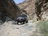
Before you begin climbing another shelf narrow cliff section of the trail, you encounter the famous Briggs Camp, and the boulder-sitting Thorndike Camp. These cabins are part of the adopt a cabin program of Death Valley National Park, which make the cabins available for travelers on a first come first serve basis, and are free of charge. Briggs cabin is amazing, and it is a must stop point of interest along the trail. If you see a flag raised it means it is occupied, and up to you to ask if you could take a peek. Nobody was staying there when we passed through, so we were free to lounge around for a bit, take some pics and stretch the legs out before driving trough what I feel is the most technical pass along this loop trail.
As soon as you drive past these 2 popular cabins, the trail begins another cliff side ascend, trough a series of narrow switchbacks offering no turn around spots for 1.5 to 2 miles.

Immediately after crossing the narrow log bridge you are greeted by “Chicken Rock” a downward tilting rock that requires utmost attention and a bit of strategy on how you expect to cross through the section to continue your journey. Since we were driving the land cruiser, a wide, and long wheel based platform, we decided to stay close to the outside edge as much as we could and then change direction after straddling the rock so the truck could come closer to the cliff wall once again.
“I think you should get out of the truck, from the other side” We were no more than 30 yards past chicken rock, when I feel the front tire loose ground and go into what felt like a ditch, immediately I put the brakes on and stop the rig. Kevin, co piloting gets out of the car to assess the situation. Once he comes over my side, I see a concerned look in his face, does a quick survey and says “ I think you should see for yourself, get out of the truck from the other side.” As soon as I heard those words I knew this could not be good. I get out of the car and see what precarious situation we were in. the truck was close to toppling over a 3 to 5 foot cliff. The front control arm was resting on the ground, driver's side front tire resting on the air, and the driver's side rear tire was an inch or two over the rock wall. One thing was clear, we had come dangerously close to flopping the vehicle, or worse, flipping. First time ever in my experience. We tried to stay calm, assess our situation, take stock of my recovery gear kit, and decided it was better to play it safe and ask for some help to the 2 guys that were staying at the rock cabin a half mile or so back down the trail. Jack and John were willing to help, and so we jumped in the back of the jeep and back up the trail towards my truck we went. We reach the bridge, and at that point we all get out of the Jeep and I spotted Jack, the driver of the Jeep, on getting past Chicken rock, I had a feeling that Jack was also feeling the butterflies in his stomach as he makes it through. Ha ha. Both the guys had been making comments how challenging it must have felt to drive such as wide vehicle through there, but honestly the land cruiser makes good work out of most of these passes. You just have to be alert at all times, and I paid the price by getting distracted where I did.
We all had our own ideas of how to tackle my vehicle's recovery, some with a certain risk I was not willing to try. Kevin and I decided to build a supporting rock wall, to provide some traction for the front tire to grip on and back out the truck at a straight angle, much like how we were when we got ourselves in this predicament. This is a good time to talk about how important it is to carry a good recovery kit when venturing off payment and away from possible help. I had chains, recovery straps, a front mounted winch, tree strap, clevis, gloves, and the versatile high-lift jack. All were within reach, except for the high-lift jack which was mounted on the driver's side and locked. It would require getting to it from the driver's side but all of us felt it was too risky approaching it because were not sure if the truck would roll and our lives were too important to risk. The idea was for me to climb the rack, unbolt the jack, and drop it to the ground, while the guys would grab on to my feet, in preparation to jerk me off the rack in case the truck would start to roll. I was not comfortable with this idea either. Jack and John had a crusty farm jack mounted to the front bumper of their jeep, but you could tell it had not been used in years, and once we managed to break the lock securing it, we realized how seized it was, thus it was of no use. So I winch the front of the truck to a rock wall using the winch cable and my tow strap, (Unfortunately I could not get the chain to hook through the winch hook and the clevis would not fit the small chain link) Kevin and I went to work and for about an hour we gathered rocks large and small and started building the support wall for the front tire to grip on. An hour's worth and a cold beer break in between, we got it to the point were we felt it was time to give our plan a try.

Jack hooked his winch to a rear recovery point on my truck, but the plan was for me to put the truck on reverse and drive myself out, and being secured with the winch from behind was to serve only as an emergency to hold my truck in place in case the truck would try to go front or get squarely along the way. I had already removed the tension from my own winch to about 6 feet, but still stayed connected just in case things would turn for the worse, at least I would have a chance to secure the front of the truck.
Luckily the recovery worked as originally planned without any issues. As it was, I managed to back out on my own. We moved the truck to a safe place, and we all were driven to the bro hand shakes, high fives and hugs. I had offered Jack and John 5 gallons of fuel for their assistance being that they also had reached the cabin with little fuel as they drove through Trona late at night and had missed the opportunity to refuel (more on this later.)
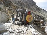
It was at that point when we see a red jeep coming down South park and soon after wards got to our location and stopped to say hello and ask if we needed help. We fill them in to our predicament, and recovery efforts, and made small chat with them. The elderly couple were on vacation and were touring a couple of the national parks around Utah, and now Death Vally. They were clearly on a rented jeep which the Jeep looked like It had some modifications to tackle some descent trails. I was busy trying to pack everything back together, assist Jack and John with refueling their jeep with the gas siphon hose etc. when I see the couple get back on their jeep say their good buys and good luck wishes and off they went to meet Chicken Rock. At this point something was telling me that I maybe should have warned them about the line I would suggest they take when getting through chicken rock, but Jack or John went over to see them get through it and perhaps offer some help. I didn't know the lady was driving, and the gentleman was doing the spotting. However, moments later I hear the engine rev louder, loud screams and at which point I get up to see what I was fearing, the jeep was severely off camber and on its way to flopping on its side, or worse, going over the cliff. Thank God the jeep only flopped, and stayed on the trail. The other option was too serious to contemplate and God only knows what faith the nice lady would have faced had it happened. I don't know why the Jeep lost control, and how it went down, the only concern at this point was to make sure the driver was safe. Kevin managed to open the driver's door and assist the woman out of the jeep. Kevin says by the time he got to her she was resting on the passenger's side and face staring down over the window and down the cliff. She was terrified. She get's help getting out of the vehicle and minus i'm sure a couple of bruises and a life scare, she was ok.
Another shot of the Jeep.
We all suggested to the couple that they walk back down to Briggs Cabin and wait for some help that was to come after we got within cell phone or (CB radio range) some good miles into the trail and possible having to come all the way back down Ballarat. At that point we noticed a Jeep Rubicon and a modified Suzuki Samurai coming up the grade.

I was hoping that party was versed in recovery techniques and offer some valuable assistance. I didn't feel our recovery experience and my reading about recovery techniques online prepared me to take a recovery leadership role right about now. I knew there were 2 options. One was much better than the second. The first was to prop the Jeep back on its wheels. The second would be to push it over the cliff (as others in the group had mentioned) so others could get through the trail. I argued that getting the Jeep back on its right side was the only way to go and that it was possible since I had seen videos and read about it of having been done. Sure enough when the other party got to the scene of the accident, the 2 more experienced drivers surveyed the situation, I suggested that maybe we could drag the fallen jeep on the side down a ways where there was more leg room to get at it from the side and try pushing it up as long as there was enough room for us to move out of the way in case it wouldn't stay up and start coming back down and flipping. The driver of the Jeep Unlimited Rubicon placed his vehicle close to the edge, and winched the fallen vehicle at such an angle that he successfully managed to get the fallen jeep to a place where we had a change to lifting back up.

It took everybody's effort 3 times, and on the third time, the Jeep came up and stayed up. This was the high point of the trip.
A team effort that goes to show how people come together as good samaritans in times of need. In those 3 to 4 hours that passed since we had gotten stuck, my buddy and I had received assistance, and we had the opportunity to pass some of that Karma on to the elderly couple.
What a good feeling that was. We also knew the goatee d, and salt and pepper haired driver of the Jeep Unlimited Rubicon would step up and finish the recovery project from there. He offered to reverse back down the section, turn around and reverse back up so he could tow the red Jeep back down the canyon to what I would assume would be Ballarat. What a nice guy and family that brought a nice ending to this part of the story. I didn't get this gentleman's name, but thanks again, and I learned much about recovery techniques from you that day. Cheers.
The clock was pushing a quarter till 4 by now. We still had some ground to cover so we said our good byes and got back on the road at a nice pace. The sun was still shining bright. It was still a great day to be out on the trail. We got to South Park Valley and admired the mountains surrounding a green valley where a lone burro was grazing, and enjoying the day. At this point there are a series of side trails that take you to different directions and former mine ruins. Kevin and I had an off road book for following directions, a GPS in hand but were tracking to the books trail directions. Still, we somehow missed the part of the trail that would take us over Roger's Pass, (the way we had ran this trail the first time,) so we ended up on the short cut, which was a steeper and more technical pass along the ridge of the Panamints.
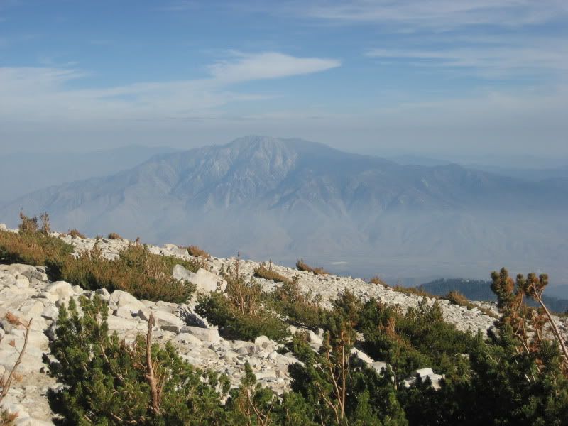
At one point we reached over 6800 feet of elevation, and there was still some spots of snow and ice along the pine tree filled range. I took my time going at pace, and letting the mule do it's thing on 4 low and both lockers engaged. Except for a couple of tricky off camber sections, it was a fun passage down into Panamint Valley. We had reached upper Pleasant Canyon, and were passing through old cabins and side trails that took you to historic mines along the way (Radcliff Mine and World Beater Mine for example.)
With plenty of sunlight left, I suggested we Stop at Clair Camp, set up camp and call it a day. We both agreed that we had had enough excitement for a day and could use the remaining day light to take our time setting up the tents, starting a nice fire and prep our tri tip meat and corn that was to be our nice dinner. Yes,we had a bottle or 2 of “two buck chuck” red wine to complement our grilled tri tip.

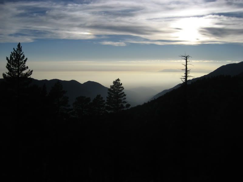
Burning a bomb fire when allowed, is Kevin's most favorite camping activity and he worked on doing just that as he made sure to bring plenty of firewood from home. We ate well, relieved the day's adventure, had a couple more laughs about “you better get off from the other side” suggestion when we got stuck, and then decided to retire back to our tents, exhausted but grateful how things had turned out. The moon was shining bright and adding a nice light over the mountains and deep canyon. I did set up the tent's rain fly just in case we got rain, and to add extra shelter from the strong winds that were to come late in the evening, ad they did. So strong that it managed to wake us up and give us an opportunity to guess how soon after the tents would sway seconds after you would hear what it appeared to be a whistle as the wind would funnel through and up the narrow canyon intensifying into gusts of wind.
Things were good, the stakes were staked down fine and I managed to got back to sleep for a couple more hours. We woke up around 7 to a crisp, and chilly morning. Soon we were back in action heating up water to make some coffee and oatmeal, I got to work on cooking the rest of the eggs and soon we were enjoying a cup of good coffee with milk, oatmeal with fresh fruit, and scrambled eggs. Who says you have to rough it when you go camping? Not if you are prepared, and that we are whenever Kevin and I go camping. Soon after we drain the remaining 5 gallons of gas into the truck, put the spare tire on the roof rack (The spare tire carrier suffered some casualty I need to check as the arm is appeared to becoming loose at the point where it bolts onto the frame.) loaded everything up as secured as we could and got back on the trail around 10 AM.
We got back to Trona with the hopes of refueling the truck so we could drive back the 25 miles to Ballarat and enter Goler Wash/Mengel Pass trail. However that was not to be because both gas stations had out of order stickers on their gas pumps. I managed to get the truth about the out of order stickers from the second gas station attendant who said that it costs them about 40 grand to refill their gas tanks and I have the feeling it would take them a while to recover the costs given the relatively low traffic activity that happens in that boring town. Very disappointingly we drove out of town thinking about our options and we decided it was too risky to attempt to drive the second part of our leg, risking running out of gas in the process. Thus we got back on the road and d welled on our options. Once we back on the 15 freeway and closer to home we both felt too tired to attempt another trail run and decided to come back to my place and finish the day with a barbecue dinner at home and watch the pics from our latest adventure. And with that we wrapped up yet another successful back roads trip in a beautiful part of our state.
you can view more pics here:
http://smg.photobucket.com/albums/v228/bohemianjsr/Off%20Road%20Trips/2011%20Death%20Valley/#!cpZZ1QQtppZZ16
We left LA some time after 8 PM on Thursday, March 17th, after we had loaded up the truck with camping supplies, and food and were now prepared. The only stop we made along the way was to fuel up somewhere after getting on the 15 fwy, thinking I would have a chance to refuel in Trona, a dusty town that serves as a gateway to the Panamint Valley. It was a good thing I decided to bring both the 5 gallon gas jerry cans, and this proved to be a critical part of being prepared for else. It turns out that both gas stations were closed as we drove through Trona late at night, so we figured with a little over a half tank remaining, and the 10 gallons of fuel as reserved, we still had enough mule juice to run the trails for both days we had planned. No worries. We got to the ghost town of Ballarat at some time right past midnight. Ballarat, which except for a small general store, only ruins remain of the historic mining town, serves as the anchor point for running these trails, the upper elevations of which are within Death Valley National Park.
You have the choice to ascend Pleasant Canyon, and descend back down to Ballarat through South Park Canyon, the option we took on our first trip 2 years ago. To change the experience we decided to run it by ascending South Park canyon, and descending Pleasant canyon.
We started the morning with our usual breakfast consisting of warm cooked oatmeal, and scrambled eggs, and a tasty cup of coffee. Afterward we packed our camping gear and headed out of Ballarat around 10 AM and were forecast ed great weather, and plenty of sun on tap for the day. About 4 miles out of Ballarat, we started the ascend for a few miles on a steep but grated road that begins to narrow dramatically, and the shelf route with steep drop offs demands the driver's attention at all times. I had the transmission in 4 low, with the center lock engaged, and rear automatic locker doing its thing. A few miles in, the trail changes topography as it takes you through a narrow canyon filled with cacti plants clinging to the jagged canyon fault wall rocks. Here the things you have to be on on the look out for are large sized rocks that give you options on how drive through those obstacles. Fun, stuff for those prepared.
Before you begin climbing another shelf narrow cliff section of the trail, you encounter the famous Briggs Camp, and the boulder-sitting Thorndike Camp. These cabins are part of the adopt a cabin program of Death Valley National Park, which make the cabins available for travelers on a first come first serve basis, and are free of charge. Briggs cabin is amazing, and it is a must stop point of interest along the trail. If you see a flag raised it means it is occupied, and up to you to ask if you could take a peek. Nobody was staying there when we passed through, so we were free to lounge around for a bit, take some pics and stretch the legs out before driving trough what I feel is the most technical pass along this loop trail.
As soon as you drive past these 2 popular cabins, the trail begins another cliff side ascend, trough a series of narrow switchbacks offering no turn around spots for 1.5 to 2 miles.
Immediately after crossing the narrow log bridge you are greeted by “Chicken Rock” a downward tilting rock that requires utmost attention and a bit of strategy on how you expect to cross through the section to continue your journey. Since we were driving the land cruiser, a wide, and long wheel based platform, we decided to stay close to the outside edge as much as we could and then change direction after straddling the rock so the truck could come closer to the cliff wall once again.
“I think you should get out of the truck, from the other side” We were no more than 30 yards past chicken rock, when I feel the front tire loose ground and go into what felt like a ditch, immediately I put the brakes on and stop the rig. Kevin, co piloting gets out of the car to assess the situation. Once he comes over my side, I see a concerned look in his face, does a quick survey and says “ I think you should see for yourself, get out of the truck from the other side.” As soon as I heard those words I knew this could not be good. I get out of the car and see what precarious situation we were in. the truck was close to toppling over a 3 to 5 foot cliff. The front control arm was resting on the ground, driver's side front tire resting on the air, and the driver's side rear tire was an inch or two over the rock wall. One thing was clear, we had come dangerously close to flopping the vehicle, or worse, flipping. First time ever in my experience. We tried to stay calm, assess our situation, take stock of my recovery gear kit, and decided it was better to play it safe and ask for some help to the 2 guys that were staying at the rock cabin a half mile or so back down the trail. Jack and John were willing to help, and so we jumped in the back of the jeep and back up the trail towards my truck we went. We reach the bridge, and at that point we all get out of the Jeep and I spotted Jack, the driver of the Jeep, on getting past Chicken rock, I had a feeling that Jack was also feeling the butterflies in his stomach as he makes it through. Ha ha. Both the guys had been making comments how challenging it must have felt to drive such as wide vehicle through there, but honestly the land cruiser makes good work out of most of these passes. You just have to be alert at all times, and I paid the price by getting distracted where I did.
We all had our own ideas of how to tackle my vehicle's recovery, some with a certain risk I was not willing to try. Kevin and I decided to build a supporting rock wall, to provide some traction for the front tire to grip on and back out the truck at a straight angle, much like how we were when we got ourselves in this predicament. This is a good time to talk about how important it is to carry a good recovery kit when venturing off payment and away from possible help. I had chains, recovery straps, a front mounted winch, tree strap, clevis, gloves, and the versatile high-lift jack. All were within reach, except for the high-lift jack which was mounted on the driver's side and locked. It would require getting to it from the driver's side but all of us felt it was too risky approaching it because were not sure if the truck would roll and our lives were too important to risk. The idea was for me to climb the rack, unbolt the jack, and drop it to the ground, while the guys would grab on to my feet, in preparation to jerk me off the rack in case the truck would start to roll. I was not comfortable with this idea either. Jack and John had a crusty farm jack mounted to the front bumper of their jeep, but you could tell it had not been used in years, and once we managed to break the lock securing it, we realized how seized it was, thus it was of no use. So I winch the front of the truck to a rock wall using the winch cable and my tow strap, (Unfortunately I could not get the chain to hook through the winch hook and the clevis would not fit the small chain link) Kevin and I went to work and for about an hour we gathered rocks large and small and started building the support wall for the front tire to grip on. An hour's worth and a cold beer break in between, we got it to the point were we felt it was time to give our plan a try.
Jack hooked his winch to a rear recovery point on my truck, but the plan was for me to put the truck on reverse and drive myself out, and being secured with the winch from behind was to serve only as an emergency to hold my truck in place in case the truck would try to go front or get squarely along the way. I had already removed the tension from my own winch to about 6 feet, but still stayed connected just in case things would turn for the worse, at least I would have a chance to secure the front of the truck.
Luckily the recovery worked as originally planned without any issues. As it was, I managed to back out on my own. We moved the truck to a safe place, and we all were driven to the bro hand shakes, high fives and hugs. I had offered Jack and John 5 gallons of fuel for their assistance being that they also had reached the cabin with little fuel as they drove through Trona late at night and had missed the opportunity to refuel (more on this later.)
It was at that point when we see a red jeep coming down South park and soon after wards got to our location and stopped to say hello and ask if we needed help. We fill them in to our predicament, and recovery efforts, and made small chat with them. The elderly couple were on vacation and were touring a couple of the national parks around Utah, and now Death Vally. They were clearly on a rented jeep which the Jeep looked like It had some modifications to tackle some descent trails. I was busy trying to pack everything back together, assist Jack and John with refueling their jeep with the gas siphon hose etc. when I see the couple get back on their jeep say their good buys and good luck wishes and off they went to meet Chicken Rock. At this point something was telling me that I maybe should have warned them about the line I would suggest they take when getting through chicken rock, but Jack or John went over to see them get through it and perhaps offer some help. I didn't know the lady was driving, and the gentleman was doing the spotting. However, moments later I hear the engine rev louder, loud screams and at which point I get up to see what I was fearing, the jeep was severely off camber and on its way to flopping on its side, or worse, going over the cliff. Thank God the jeep only flopped, and stayed on the trail. The other option was too serious to contemplate and God only knows what faith the nice lady would have faced had it happened. I don't know why the Jeep lost control, and how it went down, the only concern at this point was to make sure the driver was safe. Kevin managed to open the driver's door and assist the woman out of the jeep. Kevin says by the time he got to her she was resting on the passenger's side and face staring down over the window and down the cliff. She was terrified. She get's help getting out of the vehicle and minus i'm sure a couple of bruises and a life scare, she was ok.
Another shot of the Jeep.
We all suggested to the couple that they walk back down to Briggs Cabin and wait for some help that was to come after we got within cell phone or (CB radio range) some good miles into the trail and possible having to come all the way back down Ballarat. At that point we noticed a Jeep Rubicon and a modified Suzuki Samurai coming up the grade.
I was hoping that party was versed in recovery techniques and offer some valuable assistance. I didn't feel our recovery experience and my reading about recovery techniques online prepared me to take a recovery leadership role right about now. I knew there were 2 options. One was much better than the second. The first was to prop the Jeep back on its wheels. The second would be to push it over the cliff (as others in the group had mentioned) so others could get through the trail. I argued that getting the Jeep back on its right side was the only way to go and that it was possible since I had seen videos and read about it of having been done. Sure enough when the other party got to the scene of the accident, the 2 more experienced drivers surveyed the situation, I suggested that maybe we could drag the fallen jeep on the side down a ways where there was more leg room to get at it from the side and try pushing it up as long as there was enough room for us to move out of the way in case it wouldn't stay up and start coming back down and flipping. The driver of the Jeep Unlimited Rubicon placed his vehicle close to the edge, and winched the fallen vehicle at such an angle that he successfully managed to get the fallen jeep to a place where we had a change to lifting back up.
It took everybody's effort 3 times, and on the third time, the Jeep came up and stayed up. This was the high point of the trip.
A team effort that goes to show how people come together as good samaritans in times of need. In those 3 to 4 hours that passed since we had gotten stuck, my buddy and I had received assistance, and we had the opportunity to pass some of that Karma on to the elderly couple.
What a good feeling that was. We also knew the goatee d, and salt and pepper haired driver of the Jeep Unlimited Rubicon would step up and finish the recovery project from there. He offered to reverse back down the section, turn around and reverse back up so he could tow the red Jeep back down the canyon to what I would assume would be Ballarat. What a nice guy and family that brought a nice ending to this part of the story. I didn't get this gentleman's name, but thanks again, and I learned much about recovery techniques from you that day. Cheers.
The clock was pushing a quarter till 4 by now. We still had some ground to cover so we said our good byes and got back on the road at a nice pace. The sun was still shining bright. It was still a great day to be out on the trail. We got to South Park Valley and admired the mountains surrounding a green valley where a lone burro was grazing, and enjoying the day. At this point there are a series of side trails that take you to different directions and former mine ruins. Kevin and I had an off road book for following directions, a GPS in hand but were tracking to the books trail directions. Still, we somehow missed the part of the trail that would take us over Roger's Pass, (the way we had ran this trail the first time,) so we ended up on the short cut, which was a steeper and more technical pass along the ridge of the Panamints.
At one point we reached over 6800 feet of elevation, and there was still some spots of snow and ice along the pine tree filled range. I took my time going at pace, and letting the mule do it's thing on 4 low and both lockers engaged. Except for a couple of tricky off camber sections, it was a fun passage down into Panamint Valley. We had reached upper Pleasant Canyon, and were passing through old cabins and side trails that took you to historic mines along the way (Radcliff Mine and World Beater Mine for example.)
With plenty of sunlight left, I suggested we Stop at Clair Camp, set up camp and call it a day. We both agreed that we had had enough excitement for a day and could use the remaining day light to take our time setting up the tents, starting a nice fire and prep our tri tip meat and corn that was to be our nice dinner. Yes,we had a bottle or 2 of “two buck chuck” red wine to complement our grilled tri tip.
Burning a bomb fire when allowed, is Kevin's most favorite camping activity and he worked on doing just that as he made sure to bring plenty of firewood from home. We ate well, relieved the day's adventure, had a couple more laughs about “you better get off from the other side” suggestion when we got stuck, and then decided to retire back to our tents, exhausted but grateful how things had turned out. The moon was shining bright and adding a nice light over the mountains and deep canyon. I did set up the tent's rain fly just in case we got rain, and to add extra shelter from the strong winds that were to come late in the evening, ad they did. So strong that it managed to wake us up and give us an opportunity to guess how soon after the tents would sway seconds after you would hear what it appeared to be a whistle as the wind would funnel through and up the narrow canyon intensifying into gusts of wind.
Things were good, the stakes were staked down fine and I managed to got back to sleep for a couple more hours. We woke up around 7 to a crisp, and chilly morning. Soon we were back in action heating up water to make some coffee and oatmeal, I got to work on cooking the rest of the eggs and soon we were enjoying a cup of good coffee with milk, oatmeal with fresh fruit, and scrambled eggs. Who says you have to rough it when you go camping? Not if you are prepared, and that we are whenever Kevin and I go camping. Soon after we drain the remaining 5 gallons of gas into the truck, put the spare tire on the roof rack (The spare tire carrier suffered some casualty I need to check as the arm is appeared to becoming loose at the point where it bolts onto the frame.) loaded everything up as secured as we could and got back on the trail around 10 AM.
We got back to Trona with the hopes of refueling the truck so we could drive back the 25 miles to Ballarat and enter Goler Wash/Mengel Pass trail. However that was not to be because both gas stations had out of order stickers on their gas pumps. I managed to get the truth about the out of order stickers from the second gas station attendant who said that it costs them about 40 grand to refill their gas tanks and I have the feeling it would take them a while to recover the costs given the relatively low traffic activity that happens in that boring town. Very disappointingly we drove out of town thinking about our options and we decided it was too risky to attempt to drive the second part of our leg, risking running out of gas in the process. Thus we got back on the road and d welled on our options. Once we back on the 15 freeway and closer to home we both felt too tired to attempt another trail run and decided to come back to my place and finish the day with a barbecue dinner at home and watch the pics from our latest adventure. And with that we wrapped up yet another successful back roads trip in a beautiful part of our state.
you can view more pics here:
http://smg.photobucket.com/albums/v228/bohemianjsr/Off%20Road%20Trips/2011%20Death%20Valley/#!cpZZ1QQtppZZ16
Friday, September 3, 2010
Vivian Creek Trail to Gorgonio Peak
During the last weekend of July, my friends Kevin, Chris and I did a local hike to Gorgonio Peak, the tallest peak in so cal at 11,499 feet. We made it an overnight backpacking hike and camped out at Halfway Camp, a lower elevation campsite about 1/4 of the way to the top. The nice thing about this campsite, is that it allows you to set up camp and unload some of the weight earlier into the hike, making things easier the rest of the way.
Campsite Pics

Vivian Creek trail is known for being one of the tougher hikes in the area due to its consistent elevation gain of 5,600 feet (1 vertical mile) on its 8 mile hike to the top of Gorgonio Peak, while offering the hiker very little rest, with flat sections. The trail tests your endurance from the very beginning as the first 2 miles of the trail take you through some of the steepest part of the trail. The trail also makes you work extra hard the last 2 miles of the trail, as it once again becomes the steepest as you begin the ridge that leads you to the peak.
It is a scenic trail that tests your endurance, and cardio shape on its 16.5 mile round trip distance. It certainly helps being in shape for this trail. However, those that get to the top are blessed with great views of the Coachella Valley, San Jacinto Mountains, and the local San Bernardino Mountains.
Pics From the Top

Sunset Views
Campsite Pics
Vivian Creek trail is known for being one of the tougher hikes in the area due to its consistent elevation gain of 5,600 feet (1 vertical mile) on its 8 mile hike to the top of Gorgonio Peak, while offering the hiker very little rest, with flat sections. The trail tests your endurance from the very beginning as the first 2 miles of the trail take you through some of the steepest part of the trail. The trail also makes you work extra hard the last 2 miles of the trail, as it once again becomes the steepest as you begin the ridge that leads you to the peak.
It is a scenic trail that tests your endurance, and cardio shape on its 16.5 mile round trip distance. It certainly helps being in shape for this trail. However, those that get to the top are blessed with great views of the Coachella Valley, San Jacinto Mountains, and the local San Bernardino Mountains.
Pics From the Top
Sunset Views
Sunday, June 6, 2010
Puerto Vallarta and Guadalajara Trip May 2010
It was in my plans to make another trip down to see my extended family in Puerto Vallarta, and Guadalajara. With a bit of planning and budgeting, I decided that May was as good a month to make the drive and spend a couple of weeks in Mexico. I also wanted to do some exploration of Mexico's Western Sierra Madre, and specially la Sierra Huichol as the part of the sierra where one of Mexico's most colorful indigenous people still live.
There is much media attention about the crime waves going on in Mexico. I believe that much of the media is sensationalized, and with a bit of precaution, and common sense, Mexico still offers both local and international travelers a great experience and fun memories. I made the drive down to Guadalajara in 2 days, that is roughly 1300 miles, and a lot of gas refuel-ling. So needless to say the days were long, and I didn't stop to do any sight seeings anywhere, but stopped only to refuel, have some food, and to get some sleep in a comfortable hotel.
As far as check points were concerned, there were plenty. But all my documents were in order, including the vehicle importation permit, which was requested during a couple of the check points on the way down. Besides that, the check points were a non issue, on the way down and on the return trip. It is helpful to be respectful and friendly to the authorities and be open to small chat if requested. Besides the usual questions of our destination and purpose of the trip, I had to answer a few questions regarding my vehicle, which tends to get a fair share of attention.
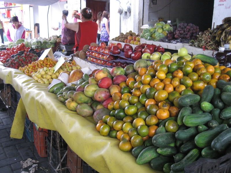
We stayed in Guadalajara 3 days, given us just enough time to spend some time with family. One day was spent doing some shopping in Tonala, which is a great hand crafts and arts market. We also went to the busy market San Juan De Dios, which also offers the shopper a variety of goods ranging from traditional garments, to fruits and vegetable stands. That area is bustling with people as the colonial is a densely populated and filled with neighborhood restaurants and stores.
Tonala Fruit Stand
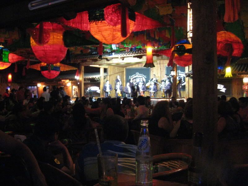
That same night I was invited by my cousin Livier, her husband Roberto and niece Nayeli to the hip Chapultepec district for a night out in the town and we went Casa Bariachi, a lively place that played good Mariachi music and served good traditional Mexican food, along with a complete list of tequila, and beer selection.
Casa Bariachi in Action
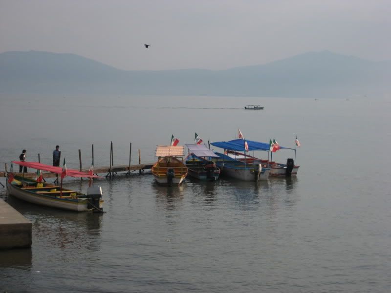
While in Guadalajara we also took a short drive to Laguna de Chapala and drove through the lake's quaint neighborhoods like Ajijic. I really enjoyed driving trough the area, and I wish I could have stayed a couple days there just being a tourist and enjoying the lake views and walking the neighborhoods' cobble stone streets filled with old colonial homes.
Laguna de Chapala

Soon it was time to move on to visit my cousin Rosita's cattle ranch near El Llano Grande, Jalisco. To get it would require we drive through Talpa, a town mostly known for its Virgen de Talpa, and its temple. Talpa gets a large amount of visitors who make the pilgrimage trail to give thanks to the Virgen de Talpa who is known for her miracles. Talpa is located about 3,900 feet above sea level, on the Sierra Madre.
Talpa De Allende, Jalisco

The dirt road can be scenic, specially near the top of the sierra as it is a series of switchbacks to get to the lower elevations.
There are also a couple of water crossings that can be a real challenge during the rainy season. Last year at the water crossing where the bridge is being built, a gentleman lost his life when he attempted to cross the river in his truck during a recent storm. To his bad luck, he got caught in the middle of the water crossing by a surging river, dragging his brand new truck about 100 yards, and tumbling it, along with him inside it. Sadly, his lifeless body was found many more yards down river hours later.
water crossing
We used El Llano Grande as a resting place, as we were busy out and about driving around visiting near by villages like El Cimarron, were we spent a bit of time by the river. The next day we headed off to the cousin's ranch a couple of miles south of town to spend the day.
El Rancho de Rosita
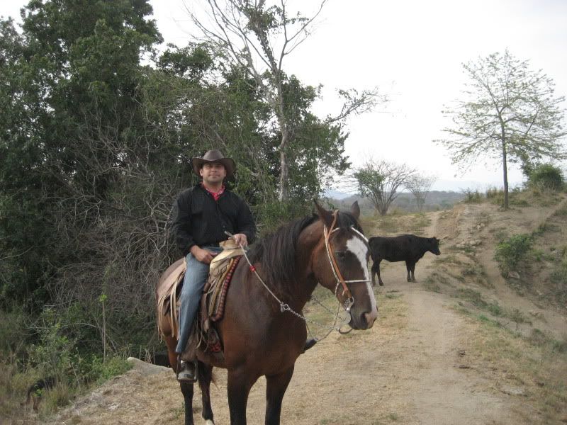
I managed to play cowboy for a day, as I was offered a well trained horse to ride, which called for me wearing some boots, along with the spurs, something no self respecting vaquero would ride a horse without. Some of us at the ranch went down to the river and dipped in the pools. After wards we ate some great food consisting of beef stew and chicken soup comprised of a freshly killed gallina (chicken) from the ranch stock, along with fresh grown vegetables. Soon after I got on my horse and went up in the hills exploring with one of my young nephews, who happened to be a much better cowboy, as at the ripe age of 13, he is a master with the rope and skilled at riding horses.
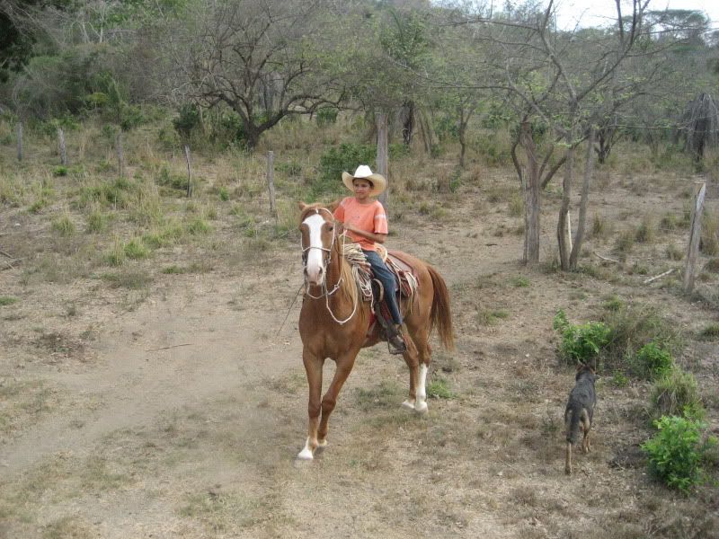
Anyways, I got the opportunity to brush my horse back riding skills and assisted in herding some of the cattle roaming on the ranch property up in the hills and brought them back down to the lower level. Again, that was a fun day for all of us, especially for me.
I only wish the river would have had more water flowing, as it would have given me yet another opportunity to test my water crossing skills on my Land Cruiser. During the rainy season, that river can be impassable as it becomes too strong and can drag cars, and horses along with its riders down river.
Early morning the day after, we loaded up the SUV and once again got on the road towards Puerto Vallarta via Tomatlan. From Llano Grande, it is about a 35 mile drive on a washboard road to reach Tomatlan.
On the Way to Tomatlan, Jalisco
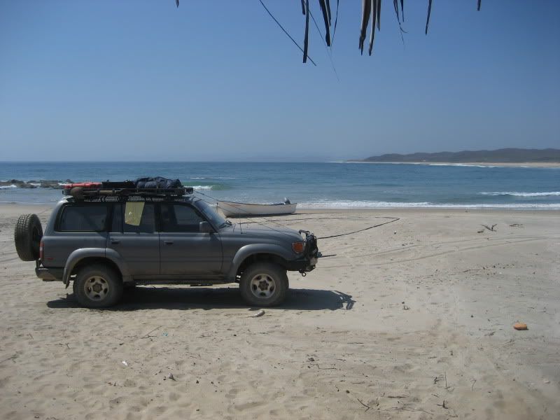
However, due to the poor stage that the road is in the drive is very slow going. Furthermore, washboard roads can be brutal on a car, and its passengers. One is forced to adapt to the road conditions and in this case, we could only go slow in most cases. At one point, even the Hi-Lift jack came loose from its jack mount, nearly braking the side window. Luckily I managed to stop the vehicle immediately after I saw the jack hit the window and then rest on it. That was a close call. I have to hand it to the engineers for making those windows so sturdy against impact, those Hi-Lift jacks are not light. After making our way past Tomatlan, we took a detour at Cruz De Loreto a few miles north of Tomatlan. My goal was to visit a local beach north from Cruz De Loreto. I had previously seen some video footage on YouTube and had read a bit about the natural beauty and pristine location of Punta Peñitas. Once we got there I was not disappointed. The beach was exactly as I had imagined it to be. Pristine and devoid of any infrastructure or services within its vicinity. You have to plan ahead and buy provisions and food at Cruz de Loreto. There are no services at Punta Peñitas, but a few ramadas to take shelter from the sun. Unfortunately the surf was small at 2-3 foot. But I still managed to paddle out for a solo surf session and catch a few waves around the middle of the beach. I can see how there could be some potential for catching some good surf on a day where there is a South or North Swell running. I specially enjoyed how clean and clear the water was, as you could easily see the bottom, along with schools of very small fish colonies swimming around you. My mom, uncle Luis and cousin Ester also enjoyed themselves trolling the beach and getting in its cool water. It was a win. I loved the beach for its remoteness, scenic qualities and surf potential.
Some Pics of Punta Peñitas

About an hour and half after we got back on the main road at Cruz de Loreto, we reached Puerto Vallarta. Again I stayed in town a little over a week, spending time with more family and attending some family parties and get together. I also took the opportunity to do some maintenance on my truck thanks to my cousin Pin, who works along with my uncle runs an auto repair shop in town. It was during this time that I noticed a small radiator leak coming from the top. After careful consideration and sound advice, I decided to use some radiator stop leak and see if that could be a temporary solution to the leaky radiator problem. It turned out as expected, and didn't see any more water leaks during the rest of the days. Some of the activities I did while in Puerto Vallarta was drive up the coast and visit San Francisco, Nayarit, where I invited one of my aunts, cousin Isabel, and my mother and had a good lunch at one of the restaurants on the beach. The food was as expected, fresh and delicious.
Seeing how there was a south swell in the 6-8 foot range, I had to paddle out for a surf session after lunch. The surf was consistent on the sets, but as typical of the place, the waves can close out so you had to be patient and choosy and wait for the set waves with the better shape. I managed to snag a couple and worked the carvable outside sections into the inside where it was either giving you an opportunity to pull in for a close out barrel, or float the section and hope for the best.

After wards I stopped by my little shack 4 blocks up the beach, and visited with some relatives I have in San Pancho. Later on at night I went out with Judith and Isabel for a walk down the malecon and ended up at La Bodegita Del Medio, a fun Cuban restaurant and bar that has live Salsa and tropical music. It was a great time and a classic day. The kind of days you look forward to experiencing during your travels. We had some much fun at that place that we went back another time.
After getting the preventative maintenance on my vehicle out of the way, I was ready to look into the trip to the Sierra De Los Huicholes. I will write about it on a separate blog, as it warrants its own focus.
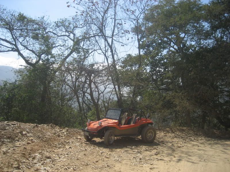
Other fun stuff I did while in Puerto Vallarta was going up some dirt roads on my Cousin Pin's boogie. It was a blast going up the Sierra Madre's switchbacks on an VW powered open top boogie.
Another time I got the opportunity to try my horse back riding skills again and make a horse dance, which I am happy to say I made it dance. It was something I always wanted to try, and am glad for the gentleman who loaned me his well trained horse during the course of a song. This happened on the night some of us went out to celebrate cousin Isabel's birthday at a hip local campestre retaurant and bar in town. I also took another family trip to Mascota, Jalisco, where we had a really nice country style lunch at a restaurant at the Village of La Estancia. This is become some sort of tradition for the uncle and aunt, whom make it a point to stop there for either breakfast or lunch on the way to Mascosta whenever they decide to get away from PV.
I didn't want to come back so soon. But the reality was that I had some things to take care of at home. I got on the road on a Tuesday morning and returned traveling the same autopistas (toll highways) we had traveled down. We rested in Navojoa Sonora for the night and were back on the road early the next day, covering some 700 miles on the second day to make it back home in 2 days. Again, had no issues on the road, at the various check points. I even got lucky and didn't have to go through the dreaded secondary inspection when crossing the border into the United States, something I somehow expect whenever you tell the border patrol officer that you traveled pretty far south like Puerto Vallarta. Maybe it had something to do with the relatively young and cute female border patrol agent who asked me the usual questions, was professional yet had a hint of friendliness.
Here is a link for more pics.
http://smg.photobucket.com/albums/v228/bohemianjsr/60%20Puerto%20Vallarta_Talpa_San%20Pancho%20May/?albumview=slideshow
There is much media attention about the crime waves going on in Mexico. I believe that much of the media is sensationalized, and with a bit of precaution, and common sense, Mexico still offers both local and international travelers a great experience and fun memories. I made the drive down to Guadalajara in 2 days, that is roughly 1300 miles, and a lot of gas refuel-ling. So needless to say the days were long, and I didn't stop to do any sight seeings anywhere, but stopped only to refuel, have some food, and to get some sleep in a comfortable hotel.
As far as check points were concerned, there were plenty. But all my documents were in order, including the vehicle importation permit, which was requested during a couple of the check points on the way down. Besides that, the check points were a non issue, on the way down and on the return trip. It is helpful to be respectful and friendly to the authorities and be open to small chat if requested. Besides the usual questions of our destination and purpose of the trip, I had to answer a few questions regarding my vehicle, which tends to get a fair share of attention.
We stayed in Guadalajara 3 days, given us just enough time to spend some time with family. One day was spent doing some shopping in Tonala, which is a great hand crafts and arts market. We also went to the busy market San Juan De Dios, which also offers the shopper a variety of goods ranging from traditional garments, to fruits and vegetable stands. That area is bustling with people as the colonial is a densely populated and filled with neighborhood restaurants and stores.
Tonala Fruit Stand
That same night I was invited by my cousin Livier, her husband Roberto and niece Nayeli to the hip Chapultepec district for a night out in the town and we went Casa Bariachi, a lively place that played good Mariachi music and served good traditional Mexican food, along with a complete list of tequila, and beer selection.
Casa Bariachi in Action
While in Guadalajara we also took a short drive to Laguna de Chapala and drove through the lake's quaint neighborhoods like Ajijic. I really enjoyed driving trough the area, and I wish I could have stayed a couple days there just being a tourist and enjoying the lake views and walking the neighborhoods' cobble stone streets filled with old colonial homes.
Laguna de Chapala
Soon it was time to move on to visit my cousin Rosita's cattle ranch near El Llano Grande, Jalisco. To get it would require we drive through Talpa, a town mostly known for its Virgen de Talpa, and its temple. Talpa gets a large amount of visitors who make the pilgrimage trail to give thanks to the Virgen de Talpa who is known for her miracles. Talpa is located about 3,900 feet above sea level, on the Sierra Madre.
Talpa De Allende, Jalisco
The dirt road can be scenic, specially near the top of the sierra as it is a series of switchbacks to get to the lower elevations.
There are also a couple of water crossings that can be a real challenge during the rainy season. Last year at the water crossing where the bridge is being built, a gentleman lost his life when he attempted to cross the river in his truck during a recent storm. To his bad luck, he got caught in the middle of the water crossing by a surging river, dragging his brand new truck about 100 yards, and tumbling it, along with him inside it. Sadly, his lifeless body was found many more yards down river hours later.
water crossing
We used El Llano Grande as a resting place, as we were busy out and about driving around visiting near by villages like El Cimarron, were we spent a bit of time by the river. The next day we headed off to the cousin's ranch a couple of miles south of town to spend the day.
El Rancho de Rosita
I managed to play cowboy for a day, as I was offered a well trained horse to ride, which called for me wearing some boots, along with the spurs, something no self respecting vaquero would ride a horse without. Some of us at the ranch went down to the river and dipped in the pools. After wards we ate some great food consisting of beef stew and chicken soup comprised of a freshly killed gallina (chicken) from the ranch stock, along with fresh grown vegetables. Soon after I got on my horse and went up in the hills exploring with one of my young nephews, who happened to be a much better cowboy, as at the ripe age of 13, he is a master with the rope and skilled at riding horses.
Anyways, I got the opportunity to brush my horse back riding skills and assisted in herding some of the cattle roaming on the ranch property up in the hills and brought them back down to the lower level. Again, that was a fun day for all of us, especially for me.
I only wish the river would have had more water flowing, as it would have given me yet another opportunity to test my water crossing skills on my Land Cruiser. During the rainy season, that river can be impassable as it becomes too strong and can drag cars, and horses along with its riders down river.
Early morning the day after, we loaded up the SUV and once again got on the road towards Puerto Vallarta via Tomatlan. From Llano Grande, it is about a 35 mile drive on a washboard road to reach Tomatlan.
On the Way to Tomatlan, Jalisco
However, due to the poor stage that the road is in the drive is very slow going. Furthermore, washboard roads can be brutal on a car, and its passengers. One is forced to adapt to the road conditions and in this case, we could only go slow in most cases. At one point, even the Hi-Lift jack came loose from its jack mount, nearly braking the side window. Luckily I managed to stop the vehicle immediately after I saw the jack hit the window and then rest on it. That was a close call. I have to hand it to the engineers for making those windows so sturdy against impact, those Hi-Lift jacks are not light. After making our way past Tomatlan, we took a detour at Cruz De Loreto a few miles north of Tomatlan. My goal was to visit a local beach north from Cruz De Loreto. I had previously seen some video footage on YouTube and had read a bit about the natural beauty and pristine location of Punta Peñitas. Once we got there I was not disappointed. The beach was exactly as I had imagined it to be. Pristine and devoid of any infrastructure or services within its vicinity. You have to plan ahead and buy provisions and food at Cruz de Loreto. There are no services at Punta Peñitas, but a few ramadas to take shelter from the sun. Unfortunately the surf was small at 2-3 foot. But I still managed to paddle out for a solo surf session and catch a few waves around the middle of the beach. I can see how there could be some potential for catching some good surf on a day where there is a South or North Swell running. I specially enjoyed how clean and clear the water was, as you could easily see the bottom, along with schools of very small fish colonies swimming around you. My mom, uncle Luis and cousin Ester also enjoyed themselves trolling the beach and getting in its cool water. It was a win. I loved the beach for its remoteness, scenic qualities and surf potential.
Some Pics of Punta Peñitas
About an hour and half after we got back on the main road at Cruz de Loreto, we reached Puerto Vallarta. Again I stayed in town a little over a week, spending time with more family and attending some family parties and get together. I also took the opportunity to do some maintenance on my truck thanks to my cousin Pin, who works along with my uncle runs an auto repair shop in town. It was during this time that I noticed a small radiator leak coming from the top. After careful consideration and sound advice, I decided to use some radiator stop leak and see if that could be a temporary solution to the leaky radiator problem. It turned out as expected, and didn't see any more water leaks during the rest of the days. Some of the activities I did while in Puerto Vallarta was drive up the coast and visit San Francisco, Nayarit, where I invited one of my aunts, cousin Isabel, and my mother and had a good lunch at one of the restaurants on the beach. The food was as expected, fresh and delicious.
Seeing how there was a south swell in the 6-8 foot range, I had to paddle out for a surf session after lunch. The surf was consistent on the sets, but as typical of the place, the waves can close out so you had to be patient and choosy and wait for the set waves with the better shape. I managed to snag a couple and worked the carvable outside sections into the inside where it was either giving you an opportunity to pull in for a close out barrel, or float the section and hope for the best.
After wards I stopped by my little shack 4 blocks up the beach, and visited with some relatives I have in San Pancho. Later on at night I went out with Judith and Isabel for a walk down the malecon and ended up at La Bodegita Del Medio, a fun Cuban restaurant and bar that has live Salsa and tropical music. It was a great time and a classic day. The kind of days you look forward to experiencing during your travels. We had some much fun at that place that we went back another time.
After getting the preventative maintenance on my vehicle out of the way, I was ready to look into the trip to the Sierra De Los Huicholes. I will write about it on a separate blog, as it warrants its own focus.
Other fun stuff I did while in Puerto Vallarta was going up some dirt roads on my Cousin Pin's boogie. It was a blast going up the Sierra Madre's switchbacks on an VW powered open top boogie.
Another time I got the opportunity to try my horse back riding skills again and make a horse dance, which I am happy to say I made it dance. It was something I always wanted to try, and am glad for the gentleman who loaned me his well trained horse during the course of a song. This happened on the night some of us went out to celebrate cousin Isabel's birthday at a hip local campestre retaurant and bar in town. I also took another family trip to Mascota, Jalisco, where we had a really nice country style lunch at a restaurant at the Village of La Estancia. This is become some sort of tradition for the uncle and aunt, whom make it a point to stop there for either breakfast or lunch on the way to Mascosta whenever they decide to get away from PV.
I didn't want to come back so soon. But the reality was that I had some things to take care of at home. I got on the road on a Tuesday morning and returned traveling the same autopistas (toll highways) we had traveled down. We rested in Navojoa Sonora for the night and were back on the road early the next day, covering some 700 miles on the second day to make it back home in 2 days. Again, had no issues on the road, at the various check points. I even got lucky and didn't have to go through the dreaded secondary inspection when crossing the border into the United States, something I somehow expect whenever you tell the border patrol officer that you traveled pretty far south like Puerto Vallarta. Maybe it had something to do with the relatively young and cute female border patrol agent who asked me the usual questions, was professional yet had a hint of friendliness.
Here is a link for more pics.
http://smg.photobucket.com/albums/v228/bohemianjsr/60%20Puerto%20Vallarta_Talpa_San%20Pancho%20May/?albumview=slideshow
Sunday, October 25, 2009
An Introduction to Tahquitz Rock
Today, my friend and rock climbing partner Kevin and I found ourselves having to scramble down a steep mountain on our butts literary. I probably had more butt time than Kevin for that matter. Part of it was due to the steep terrain that we found ourselves on. We were on the base of Tahquitz rock, a statuesque monolith of granite rock located above the mountain town of Idyllwild in San Bernardino County, on the western slope of the San Jacinto mountain range.
But there were other reasons besides the steep angles we were dealt with. One main reason being the trails were loosely defined, so we took a what you would call a straight scramble down from the location we had been rock climbing earlier on the rock’s west face. Perhaps yet another reason was that it was the first time we were exploring the rock, so besides carrying a hand written map of the area, a book of Tahquitz rock climbs, we could not really easily identity a traditional trail to and from the mountain, a sentiment shared by another pair of rock climbers at the parking lot who said they always seen to come down a different trail during their climbing sessions there. Well, to be fair, one trail on the hand written map sheet, had a 3.9 mile trail description to our destination, but we were leaning to the trail directions I had downloaded from a rock climbers’ website off the internet that said it would take about 45 minutes to get to from the parking lot to the rocks west face area.
For me, yet another reason was that my Keen sandals, in spite of being impressed for their multi use and descent rock grip and ankle support, did not fair so well scrambling down over loose dirt and rock debris, in addition to dry pine tree needles that covered most of the solid rock base underneath all that. I guess the Keen sport sandal’s wide foot design made it difficult to dig the foot into the soil for additional grip. Needless to say I was slipping and sliding for most of my way down, and trying to get down the mountain before sunset (we finished our climbs and packed up sometime after 4pm.) Ironically, the actual climbs Kevin and I did on the rock’s face earlier turned out to be much more mild than the harrowing scramble descent down the mountain. Both Kevin and I agreed that it would have been much safer and better to have double taken a look at the long way back on the “defined” trail than the option we took, but at least we did manage to get to the parking lot in 45 minutes. Maybe the poster on the rock climbers’ website was right after all. All in all, I did take a couple of spills, but I felt limber and with quick reflexes, and obviously only suffered external scratches, but got down safely and injury free.
The day started early for both of us, as we left our home bases fairly early in the morning and met in the town of Idyllwild around 9:30 AM for a planned day of multi pitch rock climbing session on the famous local rock. After doing some research and taken into account my relatively short rock climbing experience (I might as well mention that I am afraid of heights.) we decided to look for climbs in the 5.3 to 5.6 range, and rating typically describing a climb adequate but challenging enough for beginner to intermediate rock climber. This was a first time climbing the rock for both of us. I must say that the rock sits in a forest area that has breath taking views from all angles. At the base from where you start your climbs, you are already standing above elevations of 7,000 feet. You can see as far as your eyes can see to the West, and North, to the east, your view is blocked by a towering San Jacinto mountain range, covered with huge pine trees.
Also, the cool and sunny morning day turned into a perfect and mild 72 degree weather day, and stayed completely sunny. Sunny and warm enough to shed some layers of clothes and soak in the sun rays while we prepared our gear for the climb.
After some consideration we made it over the West facing side of the rock and did a 2 pitch climb on a fun, but challenging route.

Being that we don’t climb with enough frequency, we took extra time to review and go over climbing fundamentals, things like rope management, the important rope knot styles, setting safeties, belaying and communication, and securing one self to the rock where you prepare to proceed with the second pitch. A pitch is a section of a cliff that is climbed between two belay points (where one climbing partner is providing support and safety for the other as he/she climbs.) The length of a pitch is determined usually by a variety of factors, including a good belay ledge, rope drag, solid rock, and the length of rope. Pitches are never longer than the length of a climbing rope, which is either 165 feet or 200 feet. Most pitches on long climbs are between 100 and 160 feet long. Here is Kevin, going over the climb details on the reference book.
I always find it easier to climb up the rock than go down, and besides being more difficult to come down a rock, I also have to learn to control my fear of heights, something you don’t get hung up on, while you are going up the rock because your are too focused on finding a way to climb up the rock and have little need to look down. That is why I focus on the rock sections closest to me, and what is above, and avoid having to look down from where I am on the rock. The goal is to keep moving cautiously. “Cautious but keep moving” I tell myself.

All in all it was a great day spent outside doing an activity outdoors we both enjoy, and agreed that we need to plan a couple more rock climbing days in the near future. Since the season is changing and things will only get colder and the mountain will soon get it’s first snow in the weeks to come, those climbing sessions will probably occur in Joshua Tree, another rock climber’s paradise, not too far from home.
But there were other reasons besides the steep angles we were dealt with. One main reason being the trails were loosely defined, so we took a what you would call a straight scramble down from the location we had been rock climbing earlier on the rock’s west face. Perhaps yet another reason was that it was the first time we were exploring the rock, so besides carrying a hand written map of the area, a book of Tahquitz rock climbs, we could not really easily identity a traditional trail to and from the mountain, a sentiment shared by another pair of rock climbers at the parking lot who said they always seen to come down a different trail during their climbing sessions there. Well, to be fair, one trail on the hand written map sheet, had a 3.9 mile trail description to our destination, but we were leaning to the trail directions I had downloaded from a rock climbers’ website off the internet that said it would take about 45 minutes to get to from the parking lot to the rocks west face area.
For me, yet another reason was that my Keen sandals, in spite of being impressed for their multi use and descent rock grip and ankle support, did not fair so well scrambling down over loose dirt and rock debris, in addition to dry pine tree needles that covered most of the solid rock base underneath all that. I guess the Keen sport sandal’s wide foot design made it difficult to dig the foot into the soil for additional grip. Needless to say I was slipping and sliding for most of my way down, and trying to get down the mountain before sunset (we finished our climbs and packed up sometime after 4pm.) Ironically, the actual climbs Kevin and I did on the rock’s face earlier turned out to be much more mild than the harrowing scramble descent down the mountain. Both Kevin and I agreed that it would have been much safer and better to have double taken a look at the long way back on the “defined” trail than the option we took, but at least we did manage to get to the parking lot in 45 minutes. Maybe the poster on the rock climbers’ website was right after all. All in all, I did take a couple of spills, but I felt limber and with quick reflexes, and obviously only suffered external scratches, but got down safely and injury free.
The day started early for both of us, as we left our home bases fairly early in the morning and met in the town of Idyllwild around 9:30 AM for a planned day of multi pitch rock climbing session on the famous local rock. After doing some research and taken into account my relatively short rock climbing experience (I might as well mention that I am afraid of heights.) we decided to look for climbs in the 5.3 to 5.6 range, and rating typically describing a climb adequate but challenging enough for beginner to intermediate rock climber. This was a first time climbing the rock for both of us. I must say that the rock sits in a forest area that has breath taking views from all angles. At the base from where you start your climbs, you are already standing above elevations of 7,000 feet. You can see as far as your eyes can see to the West, and North, to the east, your view is blocked by a towering San Jacinto mountain range, covered with huge pine trees.

Also, the cool and sunny morning day turned into a perfect and mild 72 degree weather day, and stayed completely sunny. Sunny and warm enough to shed some layers of clothes and soak in the sun rays while we prepared our gear for the climb.
After some consideration we made it over the West facing side of the rock and did a 2 pitch climb on a fun, but challenging route.
Being that we don’t climb with enough frequency, we took extra time to review and go over climbing fundamentals, things like rope management, the important rope knot styles, setting safeties, belaying and communication, and securing one self to the rock where you prepare to proceed with the second pitch. A pitch is a section of a cliff that is climbed between two belay points (where one climbing partner is providing support and safety for the other as he/she climbs.) The length of a pitch is determined usually by a variety of factors, including a good belay ledge, rope drag, solid rock, and the length of rope. Pitches are never longer than the length of a climbing rope, which is either 165 feet or 200 feet. Most pitches on long climbs are between 100 and 160 feet long. Here is Kevin, going over the climb details on the reference book.

I always find it easier to climb up the rock than go down, and besides being more difficult to come down a rock, I also have to learn to control my fear of heights, something you don’t get hung up on, while you are going up the rock because your are too focused on finding a way to climb up the rock and have little need to look down. That is why I focus on the rock sections closest to me, and what is above, and avoid having to look down from where I am on the rock. The goal is to keep moving cautiously. “Cautious but keep moving” I tell myself.
All in all it was a great day spent outside doing an activity outdoors we both enjoy, and agreed that we need to plan a couple more rock climbing days in the near future. Since the season is changing and things will only get colder and the mountain will soon get it’s first snow in the weeks to come, those climbing sessions will probably occur in Joshua Tree, another rock climber’s paradise, not too far from home.
Subscribe to:
Posts (Atom)